Re: Topock 1943
Author: pdxrailtransit
Date: 06-17-2014 - 11:00
Needles Guy Wrote:
-------------------------------------------------------
> My grandfather worked during the end of World War
> II on the new, present day bridge over the
> Colorado River. It may have even been under
> construction when this picture was taken.
>
> The single track bridge seen in the photo
> (commonly called the Red Rock Bridge) became the
> new US66 bridge shortly after Santa Fe moved over
> to its new double track bridge. Then the original
> US66 bridge, an steel-arch structure, was used for
> a pipeline. The reason US66 moved was it needed a
> stronger bridge to handle heavier loads.
>
> The Red Rock Bridge served US66 for about twenty
> years or so and then was replaced by a new,
> four-lane interstate highway bridge for I-40. The
> old Red Rock Bridge (located just south of the
> I-40 bridge if I recall) remained in place until
> about 1980 when it was demolished. Its builder's
> plaque is in the Needles Museum. The original
> US66 steel-arch bridge, now painted white, is
> still in use today for a pipeline.
>
> It should be noted that the Red Rock Bridge wasn't
> the original bridge across the Colorado River, but
> it was the first at Topock. Originally, the Santa
> Fe (Atlantic & Pacific) crossed the river just
> east of the yard at Needles and ran down the
> Arizona side to near Topock to meet the original
> grade. That original bridge was unspectuclar I
> have been told. This original right-of-way, vary
> prone to flooding is still visible in spots and
> can been followed by satellite photos.
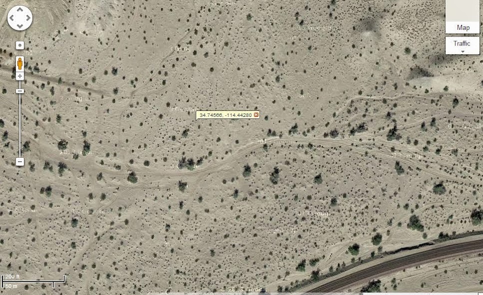
Awesome info, Needles Guy. Below is a screen shot of the location east of Topock where the old line diverged. Notice the obliteration of the RofW in the center of the photo from sediments.
-------------------------------------------------------
> My grandfather worked during the end of World War
> II on the new, present day bridge over the
> Colorado River. It may have even been under
> construction when this picture was taken.
>
> The single track bridge seen in the photo
> (commonly called the Red Rock Bridge) became the
> new US66 bridge shortly after Santa Fe moved over
> to its new double track bridge. Then the original
> US66 bridge, an steel-arch structure, was used for
> a pipeline. The reason US66 moved was it needed a
> stronger bridge to handle heavier loads.
>
> The Red Rock Bridge served US66 for about twenty
> years or so and then was replaced by a new,
> four-lane interstate highway bridge for I-40. The
> old Red Rock Bridge (located just south of the
> I-40 bridge if I recall) remained in place until
> about 1980 when it was demolished. Its builder's
> plaque is in the Needles Museum. The original
> US66 steel-arch bridge, now painted white, is
> still in use today for a pipeline.
>
> It should be noted that the Red Rock Bridge wasn't
> the original bridge across the Colorado River, but
> it was the first at Topock. Originally, the Santa
> Fe (Atlantic & Pacific) crossed the river just
> east of the yard at Needles and ran down the
> Arizona side to near Topock to meet the original
> grade. That original bridge was unspectuclar I
> have been told. This original right-of-way, vary
> prone to flooding is still visible in spots and
> can been followed by satellite photos.
Awesome info, Needles Guy. Below is a screen shot of the location east of Topock where the old line diverged. Notice the obliteration of the RofW in the center of the photo from sediments.
| Subject | Written By | Date/Time (PST) |
|---|---|---|
|
|
pdxrailtransit | 06-16-2014 - 14:37 |
|
|
George Andrews | 06-16-2014 - 20:32 |
|
|
WebDigger | 06-16-2014 - 21:40 |
|
|
Needles Guy | 06-17-2014 - 05:32 |
|
|
George Andrews | 06-17-2014 - 06:38 |
|
|
pdxrailtransit | 06-17-2014 - 11:00 |
|
|
Pilawt | 06-17-2014 - 11:06 |
|
|
Needles Guy | 06-18-2014 - 12:20 |